


Glaciers are changing fast. Rising temperatures make them melt or shrink. These changes affect rivers, sea levels, and even weather. We need to track them closely. Drone-borne SAR radar is a great tool for this. Let’s see how it works.
What Is Drone-Borne SAR?
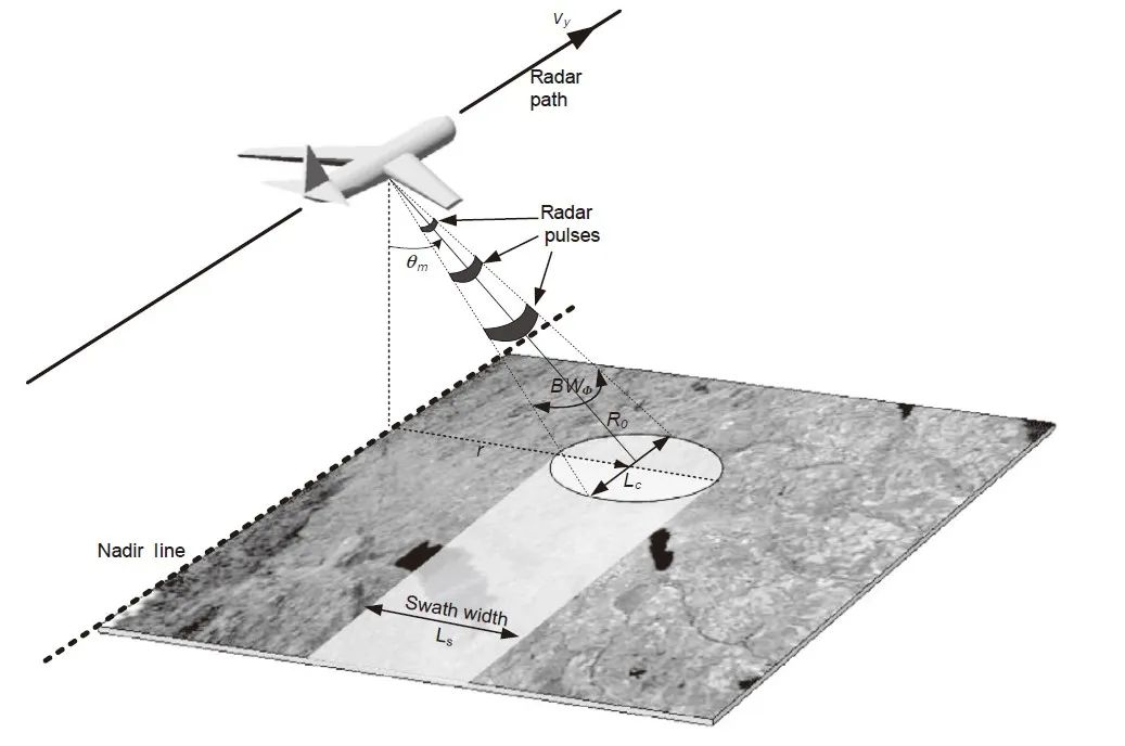
Drone-borne SAR is SAR radar mounted on drones. SAR stands for Synthetic Aperture Radar. It uses microwaves to “see” the ground—or in this case, ice.
Drones fly low and close to glaciers. This makes the SAR data more detailed. Unlike satellites, drones can reach hard-to-access ice areas. They can also fly more often, capturing frequent updates.
SAR sends out microwave signals. These signals hit the ice and bounce back. The drone’s radar catches them. Then, we turn these signals into images of the glacier.
Why Use Drones for Ice Monitoring?
Glaciers are often in remote, harsh places. Mountains, cold winds, and bad weather make them hard to study. Drones solve many of these problems.
First, drones are flexible. They can fly over small glaciers or narrow valleys. Satellites cover large areas but miss small details. Drones get up close.
Second, they are easy to deploy. You don’t need a big team or expensive equipment. A small group can launch a drone and get data in hours.
Third, they work in bad weather. Snow, fog, or low light stops optical cameras. But SAR on drones doesn’t care. It can map ice even in storms.
High-Resolution SAR: Seeing Ice in Detail
High-resolution SAR is key for ice monitoring. It creates sharp images. We can see small changes that matter.
For example, high-resolution SAR can spot cracks in the ice. These cracks might mean a glacier is splitting or melting faster. Without clear images, we might miss these signs.
It also measures how thick the ice is. Thin areas might melt first. Knowing this helps us predict how glaciers will change in the future.
How Drone-Borne SAR Tracks Glacier Changes
Measuring Ice Movement
Glaciers move slowly. They flow downhill like thick rivers. Drone-borne SAR tracks this movement.
The drone takes images of the same glacier at different times. We compare these images. We can see how far the ice has shifted—even just a few meters.
This data tells us if the glacier is moving faster or slower. Faster movement might mean it’s melting more quickly.
Detecting Melting and Thinning
Ice melts from the top and bottom. This makes glaciers thinner. Drone-borne SAR measures this thinning.
SAR signals can “penetrate” shallow snow. They bounce off the hard ice below. By analyzing the signals, we can calculate the ice’s thickness.
Comparing thickness data over months or years shows if the glacier is getting thinner. This is a clear sign of melting.
Mapping Ice Cracks and Crevasses
Cracks in glaciers—called crevasses—are dangerous. They also show how the ice is stressing. Drone-borne SAR finds these cracks easily.
High-resolution images make crevasses stand out. We can map where they are and how big they are. This helps scientists understand why the ice is cracking.
It also helps climbers and researchers stay safe. They can avoid areas with many crevasses.
Monitoring Snow Cover
Snow on top of glaciers protects the ice from sunlight. Less snow means more melting. Drone-borne SAR tracks snow cover.
SAR can tell the difference between snow and bare ice. It maps areas where snow has melted away. This shows which parts of the glacier are most at risk.
We can also measure how deep the snow is. Thick snow might slow melting. Thin snow does the opposite.
Steps to Use Drone-Borne SAR for Ice Monitoring
- Plan the Flight: Choose the glacier area to study. Decide how high the drone should fly. Lower flights give higher resolution.
- Launch the Drone: Send the drone up with the SAR radar. Make sure it follows the planned path. This ensures we cover the whole area.
- Collect Data: The drone’s SAR sends and receives signals as it flies. It stores the raw data for later use.
- Process Images: Use software to turn the raw data into ice images. These images show the glacier’s surface and structure.
- Analyze Changes: Compare new images with old ones. Look for movement, thinning, cracks, or snow loss.
- Share Findings: Tell scientists, local communities, or governments about the changes. This helps plan for water resources or flooding risks.
Advantages Over Other Ice Monitoring Tools
Drone-borne SAR has big advantages over other methods:
- Cheaper Than Satellites: Satellites cost millions to build and launch. Drones are much less expensive. Small research teams can afford them.
- More Flexible Than Ground Teams: People can’t easily reach many glaciers. Drones fly over these areas without risk.
- Works in All Weather: Optical drones or planes can’t fly in snow or fog. SAR drones keep working. They don’t need sunlight.
- Faster Data Turnaround: Satellites might take weeks to send images. Drones give data the same day. This lets us react quickly to sudden changes.
Future of Drone-Borne SAR in Ice Monitoring
Technology is getting better. New drones can fly longer—up to 24 hours. This lets them cover bigger glaciers in one trip.
High-resolution SAR is also improving. Future systems might detect changes as small as a few centimeters. This will make our ice models more accurate.
We might also see drones working together. A group of small drones could map a large glacier faster than one big drone. They could share data in real time.
Scientists are also making data easier to use. Simple apps might let local people check glacier changes. This helps communities prepare for melting ice and rising rivers.
Conclusion
Drone-borne SAR is a powerful tool for ice monitoring. It goes where other tools can’t. It works in bad weather. High-resolution SAR lets us see small changes that matter.
By tracking glaciers with drones, we learn how they’re changing. This helps us predict future melting, protect communities, and understand climate change.
As technology improves, drone-borne SAR will become even more important. It’s not just about studying ice—it’s about keeping our planet and people safe.