


As low-altitude airspace becomes the new frontline for security threats, traditional surveillance systems are no longer enough. Whether it’s a stadium packed with thousands of spectators or a critical urban facility, rogue drones pose real, escalating risks.
At the recent Ma’anshan Star Concert, a real-world threat scenario unfolded — and Fanyue Industrial’s FYDR600-A drone detection system proved it can safeguard large-scale events through real-time detection, precise pilot tracking, and actionable intelligence. Here’s how it delivered a 12-kilometer defense perimeter and ensured zero aerial incidents.
The Escalating Drone Threat at Stadiums, Venues & Critical Sites
Unmanned aerial vehicles (UAVs) have become both a tool and a threat. According to the Federal Aviation Administration (FAA), over 100 drone sightings near restricted airspace are reported monthly by pilots and air traffic controllers in the United States alone (FAA, 2025).
The International Civil Aviation Organization (ICAO) has issued dedicated guidance on protecting civil aviation infrastructure from rogue drones and unmanned aircraft systems. Their resources highlight UAS as a “growing safety and compliance risk” for national airspace and critical infrastructure.
See:
A Reuters July 2025 report confirms that over 3,000 drone-related incidents have occurred near U.S. airports and public venues since 2021, prompting new urgency in drone threat mitigation policies (Reuters, 2025).
💡 Expert Sources Confirm the Growing Threat
- 📊 FAA: 100+ drone sightings per month in U.S. restricted zones
- 🌐 ICAO: Urges global alignment on anti-drone protocols
- 📰 Reuters (Jul 2025): 3,000+ incidents since 2021 near major airports
Case Study: All-Scenario Drone Detection System at the Ma’anshan Star Concert
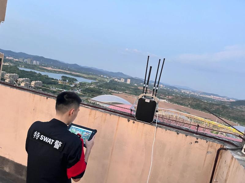
Site Challenges & Security Objectives
Held at the Ma’anshan Olympic Sports Center, the concert drew over 40,000 attendees. The urban location, combined with nighttime lighting and heavy RF interference, made the environment especially complex for traditional drone detectors.
The mission was clear: provide 360° protection against unauthorized drones, trace pilots in real time, and ensure rapid response — all without disrupting the concert experience.
Deployment Snapshot
The FYDR600-A All-Scenario Drone Detection and Positioning System was deployed in a multi-point layout, forming a 12-kilometer low-altitude surveillance network with no blind spots. Its all-scenario design enabled flexible mounting on tripods, vehicles, and elevated posts — even handheld operation when needed.
Multiple detection modes — RF signal scanning, pilot positioning, and FPV signal tracing — ensured real-time situational awareness.
Operational Results
During the event, several rogue drones were immediately locked upon takeoff. The FYDR600-A traced their flight paths and pilot positions simultaneously, even identifying operators hiding within crowds or nearby structures.
Security personnel received alerts on tablets and mobile apps, enabling:
- Real-time dispatch of ground teams
- Deployment of portable drone jammer integration devices
- Coordinated suppression of aerial threats
- Quick apprehension of drone operators
The system’s closed-loop architecture turned scattered detection data into rapid action — securing the airspace without a single breach.
Inside FYDR600-A: How the Closed-Loop Architecture Works
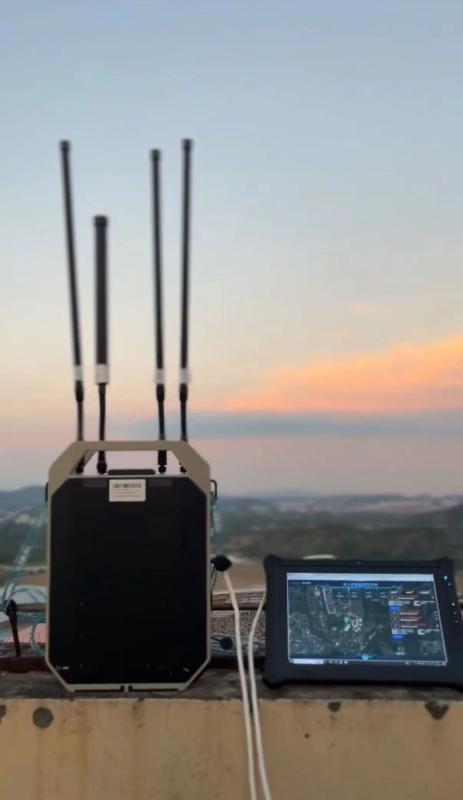
Ultra-Long-Range, Multi-Channel Detection
Unlike short-range systems limited by line-of-sight, FYDR600-A offers ≥12 km RF and FPV detection range, supporting scanning from 70 MHz to 6.2 GHz. It covers DJI, Docom, Haboson, and FPV drones — including DIY models — and identifies both drone and pilot locations with ≤10m accuracy.
Spec Snapshot:
• Detection Range: ≥12 km
• Frequencies Supported: 400 MHz to 5.8 GHz (customizable)
• FPV Image Detection: Analog + Digital, up to 6 GHz
• Detection Accuracy: ≤10m
• Power Supply: Lithium Battery, ≥6h life
Real-Time Intelligence & Mobile Alerts
The system transmits detection data to control tablets and mobile apps. Operators receive:
- Drone type and frequency
- Live location mapping
- Threat level assessment
- Task delegation options
With one-click tasking, security leaders can dispatch responders and activate countermeasures in seconds — drastically reducing the decision loop.
Evidence Collection & FPV Interception
FYDR600-A captures FPV (First-Person View) video feeds in real time. This provides:
- Visual confirmation of hostile drone activity
- Legal-grade evidence for post-incident investigation
- Valuable insights into drone type, route, and pilot intent
Top Benefits for Security Directors & Event Organizers
360° Coverage with Modular Deployment
The system supports:
- Backpack patrols
- Vehicle-mounted patrols
- Fixed tower surveillance
- Handheld deployment
This flexibility allows operators to scale based on event size, terrain, and response team mobility.
Faster Response, Lower Man-Hours
Traditional patrols rely on scattered visual surveillance. FYDR600-A’s automated alerts eliminate guesswork and reduce personnel requirements, allowing smaller teams to secure larger areas with greater speed and precision.
Regulatory Compliance & Legal Evidence
With built-in DID/RID location tracking (≥10 km), FPV footage, and traceable logs, FYDR600-A helps agencies comply with anti-drone regulations, simplifies prosecution, and supports forensic audits post-incident.
Secure Your Airspace Before the Next Event
Drone threats are invisible — until it’s too late.
Let the all-scenario drone detection and positioning system provide your team with the tools to detect, identify, and respond in real-time. Request a tailored threat assessment today to see how it performs in your unique environment.

